Category: Kubrick
-
The Weather for the Long and Short Haul is Cloudy with a Chance of Laundry
The Fan at the Laundromat, 2013, processed 2014 The Laundromat, 2013, processed 2014 We are refreshed. I redid the website to something a little more suitable temperamentally. The website, I coded. The blog has a new look as well but this template I purchased because I wanted plain good WordPress functionality without too much effort.…
-
The Road to Jericho and Oyster Bay – Revisiting “Eyes Wide Shut” – Google Maps Redux
[clear] 495 Exit – Revisiting “Eyes Wide Shut” – Google Maps Redux In Eyes Wide Shut, Bill gets his costume then sets out for the address given him by the pianist. We view the exit for 495. [clear] The next shot is in Oyster Bay. This was a tough one to find. We have just…
-
Possible Inspiration for The Rainbow – Revisiting “Eyes Wide Shut” – Google Maps Redux
This content has been updated and moved to Inspiration for the facade of Rainbow Fashions.
-
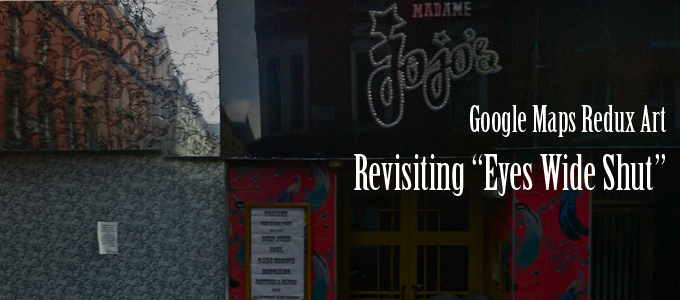
The Sonata Cafe – Revisiting “Eyes Wide Shut” – Google Maps Redux
[clear] Madame Jojo’s – Revisiting “Eyes Wide Shut” – Google Maps Redux [clear] Madame Jojo’s – Revisiting “Eyes Wide Shut” – Google Maps Redux [clear] Madame Jojo’s – Revisiting “Eyes Wide Shut” – Google Maps Redux The interior of Madame Jojo’s, in London, UK, was the set of the Sonata Cafe in Eyes Wide Shut.
-
The Back Fence – Revisiting “Eyes Wide Shut” – Google Maps Redux
[clear] The Back Fence – Revisiting “Eyes Wide Shut” – Google Maps Redux [clear] Looking the Other Direction from the Back Fence (2) – Revisiting “Eyes Wide Shut” – Google Maps Redux Another Greenwich anchor Kubrick gives us is a street corner that can be identified by the club The Back Fence. This live shot…
-
Revisiting “Eyes Wide Shut” – The Pink Pussycat – Google Maps Redux Art
[clear] The Pink Pussycat – Revisiting “Eyes Wide Shut” – Google Maps Redux [clear] Next to the Pink Pussycat – Revisiting “Eyes Wide Shut” – Google Maps Redux [clear] Down the Road from the Pink Pussycat – Revisiting “Eyes Wide Shut” – Google Maps Redux After the Greenwich anchor of 3rd and Sullivan in “Eyes…
-
3rd and Sullivan, New York – Revisiting “Eyes Wide Shut” – Google Maps Redux
[clear] 3rd Street and Sullivan – Revisiting “Eyes Wide Shut” – Google Maps Redux [clear] 3rd Street and Sullivan (2) – Revisiting “Eyes Wide Shut” – Google Maps Redux In Eyes Wide Shut, Kubrick gives us a Greenwich Village view as an anchor as Bill leaves Marion Nathanson’s apartment and begins his odyssey, but the…
-
Revisiting “Eyes Wide Shut” – Victor’s Mansion – Google Maps Redux Art
[clear] Victor’s Ball – Revisiting “Eyes Wide Shut” – Google Maps Redux [clear] The Entrance to Victor’s Supposed Mansion – Revisiting “Eyes Wide Shut” – Google Maps Redux [clear] 237 Madison, Behind Victor’s Supposed Mansion – Revisiting “Eyes Wide Shut” – Google Maps Redux Kubrick crossfades from Bill and Alice exiting the San Remo, in…
-
Revisiting “Eyes Wide Shut” – San Remo – Google Maps Redux Art
[clear] San Remo – Revisiting “Eyes Wide Shut” – Google Maps Redux Bill and Alice live at the San Remo building at 145/146 Central Park West, though the exterior of the building doesn’t fit at all with the layout of the apartment but who cares. We’re twice given this anchor, between the scenes of Alice…
-
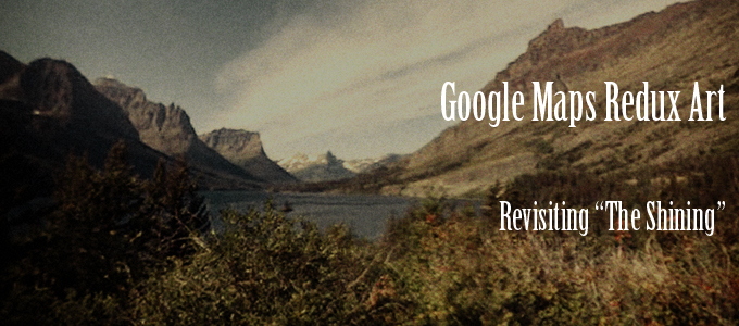
A Couple of Supplemental Pretty Shots of the Timberline Area
[clear] To the Timberline – Revisiting “The Shining” – Google Maps Redux Art [clear] To the Timberline 2- Revisiting “The Shining” – Google Maps Redux Art
-
Dick Travels up the Mountain – Revisiting “The Shining” – Google Maps Redux Art
[clear] The Snow Cat to the Rescue – Revisiting “The Shining” – Google Maps Redux Art [clear] Snow Covered Trees – Revisiting “The Shining” – Google Maps Redux Art [clear] The Overlook/Timberline from the Road – Revisiting “The Shining” – Google Maps Redux Art In the 4 P.M. section of The Shining, Dick travels in…
-
The Timberline/Overlook Blanketed in Snow – Revisiting “The Shining” – Google Maps Redux Art
[clear] Best Way to the Lodge – Revisiting “The Shining” – Google Maps Redux Art In the 8 A.M. section of “The Shining” we get a brief look of a view of the studio lodge from the far west entrance, which was unobserved on Closing Day. Though the studio set is different from the real…